You are here
Buildings
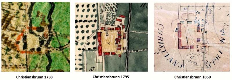
The structures at Christiansbrunn were organized as a quadrangle. The Monocacy Creek, flowing north to south, ran along the eastern border of the site. The road to and from Bethlehem, visible in the maps above, entered the southern side of the quadrangle, while the road to and from Nazareth crossed the Monocacy and entered the the eastern side of the quadrangle. A detailed survey of the property was made in 1757 by George Golkowsky.
Click here for a full list of buildings and associated trades at Christiansbrunn.
The drawing below depicts Christiansbrunn in 1755 or 1756. The artist was looking from east to west: the Monocacy Creek snakes along the foreground and the barn complex occupies the background. The Family House on the left of this drawing formed part of the south side of the Christiansbrunn quadrangle. The landscape sloped steeply from the barn complex down to the Monocacy Creek, and several of the buildings here, including the Boys' House, were built into the hill.
Historians began to try to preserve information about the settlement in the late nineteenth century. In 1873 and 1874, W. C. Reichel visited Christiansbrunn and skeched many of the structures that survived. About the same time, John Woolf Jordan copied a map of the settlement with an associated list of buildings.
The only building from eighteenth-century Christiansbrunn that survives into the twenty-first century, the Pfleger's House, had not been built when this drawing was made. It would be built between the Sawmill and the Boys' House.
Click on the yellow dot on any building to discover the use of the building--and then click on the building's name to learn more about it.
Click here for a model of the buildings of Christiansbrunn in 1757.